

A history of severe weather in Chicagoland
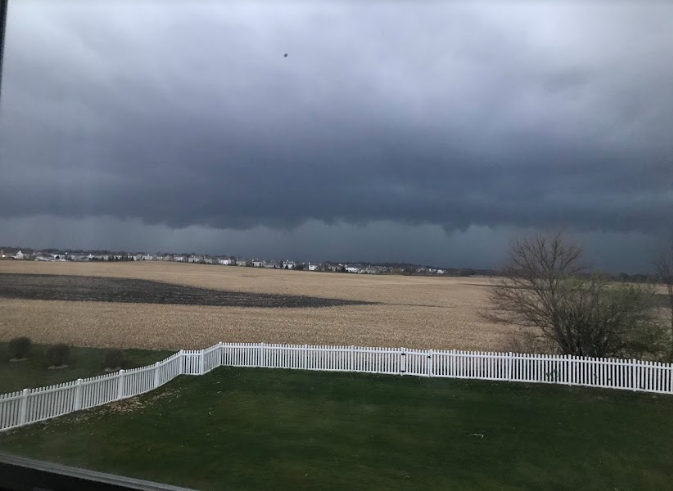
Photo By Nathan Lapitan
A storm impacts the western Chicagoland area on Nov. 10, 2020. The storm was responsible for 80 mph winds in Sugar Grove, Illinois, and produced an EF0 tornado near Maple Park, Illinois, a few minutes prior to the picture being taken.
Chicago, Illinois, home of nearly three million people, has seen its fair share of historic severe weather all across the city and its surrounding metropolitan area. From blizzards that shut down Lake Shore Drive on Groundhog Day and crippled the entire region, to a massive F5 tornado that struck the southwestern suburbs of Chicago, killing 29 people in a town with no warning prior, to record-breaking flooding and thunderstorms that interrupted the true concept of a normal day to day life, Chicago has seen it all.
Tornadoes are one of nature’s most ferocious and deadly phenomena, and the Chicago area has seen plenty of them in the city and surrounding areas since 1855. Most of these tornadoes are relatively weak and brief, however, there are always exceptions, and one exception proved extremely deadly.
Aug. 28, 1990, was a typical, but very warm and humid, Tuesday for the residents of Plainfield, Illinois. However, at 3:30 p.m., everything changed in the blink of an eye. A massive F5 tornado was bearing down on the small community of just over 5,200 people (according to the 1990 Census). In a matter of 15 minutes, the tornado would leave behind a trail of destruction that would last a lifetime, physically and psychologically. 29 people were killed and 353 were injured as a result of this tornado.
Something unusual and deadly about this tornado was that there was no tornado warning before the tornado hit, only a severe thunderstorm warning being issued, along with no indication that a large and deadly tornado was on the ground. According to WGN Chief Meteorologist Tom Skilling, “The meteorologist that was operating the weather radar in Chicago wasn’t able to tilt the radar on the computer, which would’ve made viewing the storm that would end up producing the tornado in Plainfield much easier to see.”
Without the proper warning issued, there was bound to be controversy. After the events that led to there not being a tornado warning, several meteorologists and storm chasers began to call the sequence of events, the “Plainfield Syndrome”. The phrase means it’s better to issue too many warnings and get the majority wrong rather than miss a crucial warning and cause hundreds of fatalities, which is exactly what happened in Plainfield.
One eyewitness who lived near the intersection of Illinois State Route 59 and Illinois State Route 126 and witnessed the tornado from their home said, “The tornado was so low to the ground and wrapped in rain [that] I couldn’t get a good view of it. That is what I believe to be the main reason for the high death toll in Plainfield.”
This was true for anyone viewing the tornado throughout its entire life. The nearly half-mile-wide tornado was wrapped in rain during its life, and because of this, no known photos or videos exist of the tornado itself. However, just a half hour before the tornado would touch down, a video was filmed at Northern Illinois University of the same storm that would eventually produce the F5 tornado.
Even though most historic weather events in the Chicago area occur in the form of thunderstorms that are produced high in the atmosphere, historic severe weather can occur in many different ways as well, ways that can cause hundreds of fatalities on a single day were it to occur in the correct place and affect the most vulnerable people.
Global warming is something that no one has any control over, and for the residents of the Chicago area between July 12 and July 15, 1995, global warming felt like an understatement until an extremely deadly and unprecedented heat wave impacted the area.
According to the National Weather Service Chicago office, temperatures at O’Hare International Airport on July 13, 1995, reached all-time highs of 106 degrees, with a heat index of 124 degrees. The temperature reading of 106 degrees was sustained for over six hours. With this, death was inevitable due to the number of people that live without air conditioning in Chicago.
Due to the amount of extreme heat, nearly a thousand people were killed as a result of the heat wave, most of them being senior citizens. According to someone who lived near Austin Avenue in the Austin neighborhood of Chicago, “We didn’t have air conditioning in our home, so my family and I were given free rides to cooling centers set up by the city for those without air conditioning.”
According to the same witness, most of the fatalities from this tragic heat wave occurred in apartment complexes, due to the rising heat in the upper floors of the buildings trapping people there until their ultimate demise.
From heat waves to killer tornadoes, one might think that severe weather in the Chicago area couldn’t get any worse than this. However, for the entire Chicagoland area, that statement was far from the truth when one of the largest blizzards in the metropolitan area’s history occurred on Groundhog Day, 2011.
Between Jan. 31 and Feb. 2, 2011, the now infamous “Groundhog Day Blizzard” crippled the entire Chicagoland region, with the worst affected areas being along the lakefront of Chicago. In areas from St. Charles to Waukegan to downtown Chicago, nearly two feet of non-blowing snow fell across the region. However, once the winds started picking up, that’s when the blowing snow made the effects of the blizzard even worse. Due to the strong winds associated with the storm blowing all of the snow around, some areas experienced nearly 10 feet of snow drifts.
According to the National Weather Service, the most snow fell between the hours of 6 p.m. on Feb. 1 and midnight on Feb. 2. With all of the 21.2 inches of snow that was accumulated on both days, this would be ranked as the third highest amount of snowfall in the Chicagoland area, behind the 21.6 inches that fell between Jan. 1 and Jan. 3, 1999, and the 23 inches of snow that fell on Jan. 26 and Jan. 27, 1967.
Although the past three events have been arguably historic, the August 2020 Midwest Derecho and tornado outbreak that took place in the northern parts of the Great Plains and Great Lakes regions of the United States on Aug. 10, 2020, was one of the most historic thunderstorms in American history.
This historic storm formed in southern South Dakota and eastern Nebraska late on Aug. 9 and into the early morning hours of Aug. 10. This storm would eventually become the costliest thunderstorm in American history, with total damages reaching $11 billion, according to NPR. According to the National Weather Service Quad Cities office, the storm traveled 770 miles in only 14 hours, or an average forward-moving speed of 55 miles per hour. The highest winds associated with this storm were just over 125 miles per hour, which were recorded in Cedar Rapids, Iowa, around noon.
Eventually, the derecho moved into Illinois, where it continued to cause complete chaos all across northern Illinois and further east. 16 tornadoes would touch down in Illinois, 13 being in the Chicago area alone, with the strongest being an EF1. Widespread straight-line wind damage was found as far west as Des Moines and as far east as downtown Chicago. During the entirety of the storm’s lifetime, it brought torrential rainfall to places from western Iowa to western Indiana, with the largest amount of rainfall occurring three miles northwest of Orangeville, Illinois, where 3.12 inches of rain fell. Some large hail also fell in some areas as well.
Even with all of these major events occurring in the Chicagoland area, there are always going to be people that are vulnerable to these events, regardless of the number of precautions one person takes to survive. Even with advanced warning times ahead of storms and stronger buildings being built, there are still people who either don’t pay attention to the weather or think that the storm won’t be as bad. However, in a recent interview with former KWTV News 9 chief meteorologist Gary England from Oklahoma City, he said, “Regardless of where severe weather occurs, it is always important that people take the proper precautions before the severe weather season strikes their area.”

Name: Nathan Lapitan
Position: Meteorologist
My favorite…
Movie: Twister
Show: Storm Chasers
Animal: Cat
Hobby:...